The Monumental Loop - Every good ride starts with a buzz.
Get link
Facebook
X
Pinterest
Email
Other Apps
Photo Credit: Bikepacking.com
Several months back, one of the members of our Bad Idea Club ™, Cody Wallis, pitched the next bad idea as a trip to the Chihuahuan Desert to check out the Monumental Loop, which has been created by Matt Mason, in collaboration with Jack Kirby, Dan Carter, and other Las Cruces bikepackers. (bikepacking.com)
Our crew would eventually whittle down to Cody, Justin Mace, Nick Nichols, and myself, from the Bad Idea Club ™, a friend of ours who lives in Albuquerque, Rowdy Randall Ausdran, and an old friend of Cody's and one of his friends, Ian and Austin, who were from Colorado, totaling 7 adventurers.
We opted to drive out and fly back, as one of the guys had an upcoming family vacation in the area and wanted to leave the van out there for ease of travel. March 18th became the target departure date and was upon us before we knew it. It came so fast that several of the attendees opted to just "ride themselves into shape on the route" rather than doing any measurable amount of riding prior to the adventure. Not surprising.
Friday rolled around, we all met locally, loaded up the sprinter van, and rolled out of Chattanooga around 2:30pm for a straight 20 hour push to El Paso to pick up Justin the next morning, who was flying both ways. The departure included sombreros and a mandatory drivers serape.
We picked Justin up right on time, around 10:30am the next morning, and went to find some lunch and margaritas! We had the rest of the day to just piddle around, do a short ride, and get our bikes ready to go for a Sunday morning departure.
Left to right: Myself, Justin, Nick, Cody, and his sister-in-law, Hannah, who hosted us
After accidentally ordering the world's largest margarita, we headed over to a local trail head to hang out, enjoy the afternoon sunshine, and ride a few miles just to wake the legs up. The trails were loose, gravely, and lined with many endemic species of cacti and their flesh (and tire) piercing spines! I'd find out later how irritating and painful these spines can be.
After meeting up with Ian and Austin here, we all went to a local brewery for some dinner and beers before heading back to the trailhead, which is where we decided to sleep before starting the route the next morning. Some of them slept in vans while Randall, Cody, and I slept under the pavilion, bathed in an intense moonlight all night long.
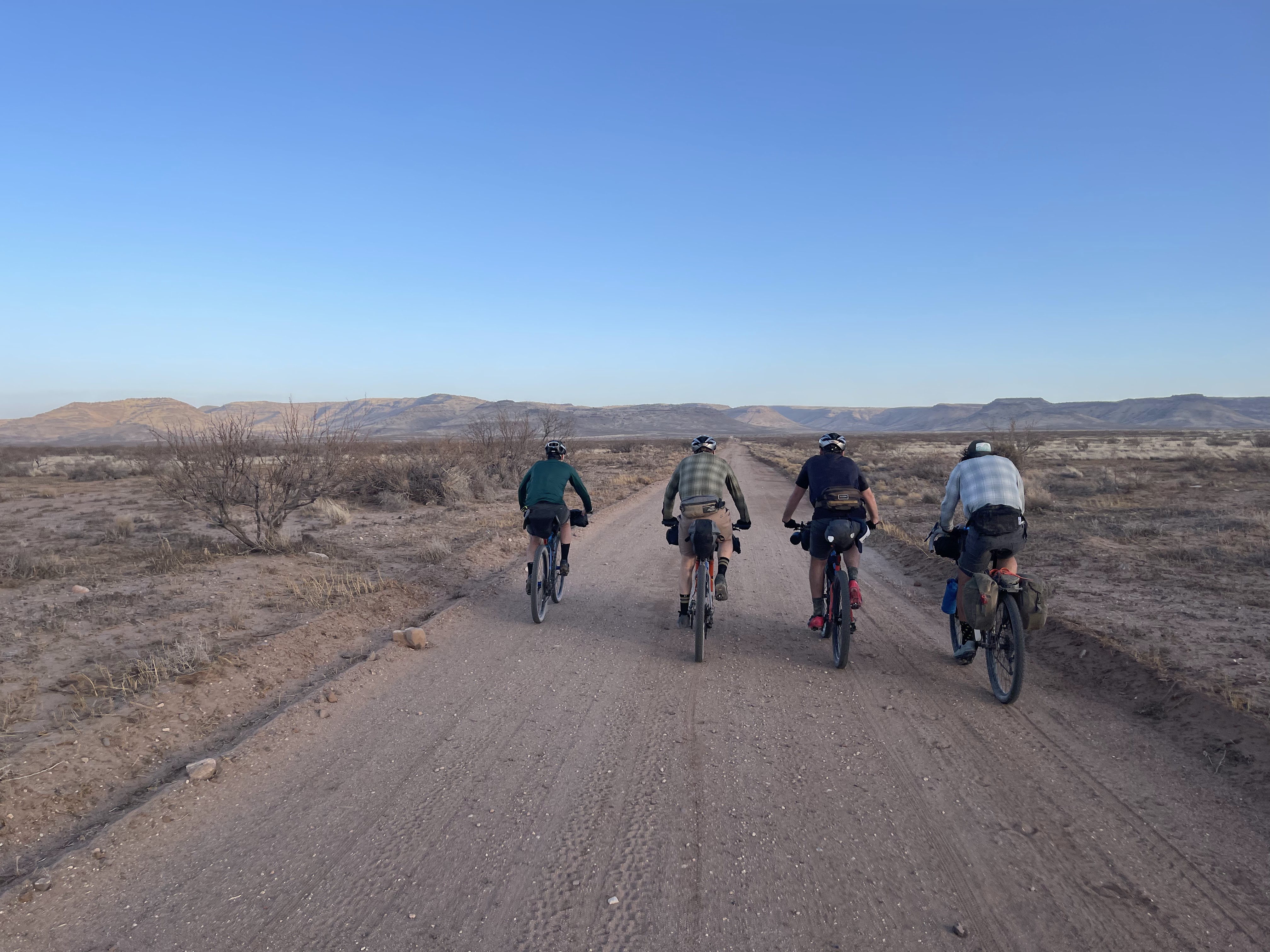
We rose around 6:00am, packed up, and drove over to the parking lot in town, where we would depart from. It was a beautiful morning, about 55 degrees, with a slight breeze providing a little chill to the air. We did our last minute bag and gear checks, toasted a naturally lightened beverage, and headed off into the unknown to experience our favorite thing, adventure.
The morning was rather uneventful and pleasant, from what I remember. We pedaled out of town on pedestrian paths and canal roads, paralleling the dried up, dusty canals, passing an innumerable amount of recently harvested pecan orchards, stucco and adobe-style houses with fenced-in dirt yards, and barking dogs giving hopeful chase down the fence lines.
Notice the Lincoln Continental that I wanted to bring home
Around 13 miles in, we hit the Organ Mountains-Desert Peaks National Monument which is a protected wilderness area managed by the Bureau of Land Management as part of the National Landscape Conservation System.
After a short section of pristine, gently rolling, finely-crushed gravel, we made a left onto our first section of single track. It was mainly flowy gravel through the scrub of the desert floor, making it's way towards a jagged mountainous backdrop.
We eventually made our way up to the craggy rock formation in the distance, navigated a short technical section with some hills, and then pedaled away, leaving it behind in search of our next attraction.
Our first stop was to be the Blue Moon Bar and Grille, about 30 miles in, where we were planning to eat lunch. I hadn't really done my research properly, and we found out they didn't open until noon and it was 11:30. We opted to just keep rolling as we didn't want to sit there for 30 minutes. In hindsight, this wasn't the best idea as, myself, and probably others, hadn't prepared to have enough food for 65 miles, which was where the second resupply option was, in Hatch, NM.
Notice the sign wording
A dry Rio Grande River bed
After our failed lunch stop, we turned left off the pavement, back into the eastern side of the OM-DP National Monument again. We started with a steep, loose, dry gravel road that took us up into the high desert, which sits about 300-400 feet above the city, from what I could gather. This was about the time that our day got a little more difficult. Our general direction turned more westward, and the winds began to pick up out of the west as well. We had talked to a local rider at the trail system the day before who had warned us about the approaching cold front, which tends to bring high winds, and something most of us hadn't heard of, called a Haboob, which is apparently a large dust storm. Well, he wasn't wrong. We were being repeatedly slapped in the face with a 25-35mph headwind with gusts up to 45-50mph. Luckily, it wasn't really kicking up enough debris to require face coverings to filter dust particles. But boy were the next 30 miles to Hatch a bit punishing! Several times I found myself having to stand and pedal into the wind, on flat ground, just to keep moving forward. It was insane!
We were in a seemingly extremely remote area with nothing but dirt, rock, and desert scrub bushes all around. Not even any wildlife to be seen! We passed through Slot Canyon and Broad Canyon, meandering back and forth across dry, sandy creek beds, slowly making our way to Hatch, thoughts of green chile burgers heavy on our minds!
We encountered our first water stop, which was a cow tank, surrounded by cow patties. There were goldfish swimming in it which, I guess, is a good sign?? Somehow I don't have a pic of us filtering, but I do have a picture of Justin commandeering a bull dozer. Not really.
After about 15 miles of this increased difficulty, we were rewarded with a long, gradual descent that was about 7 miles or so and we enjoyed every second of it!
After this section, we had about 10 miles or so of gravel road, skirting monstrous pecan orchards, to get to the town of Hatch. Unfortunately, some of the worst winds were encountered in this section, but, we got it done.
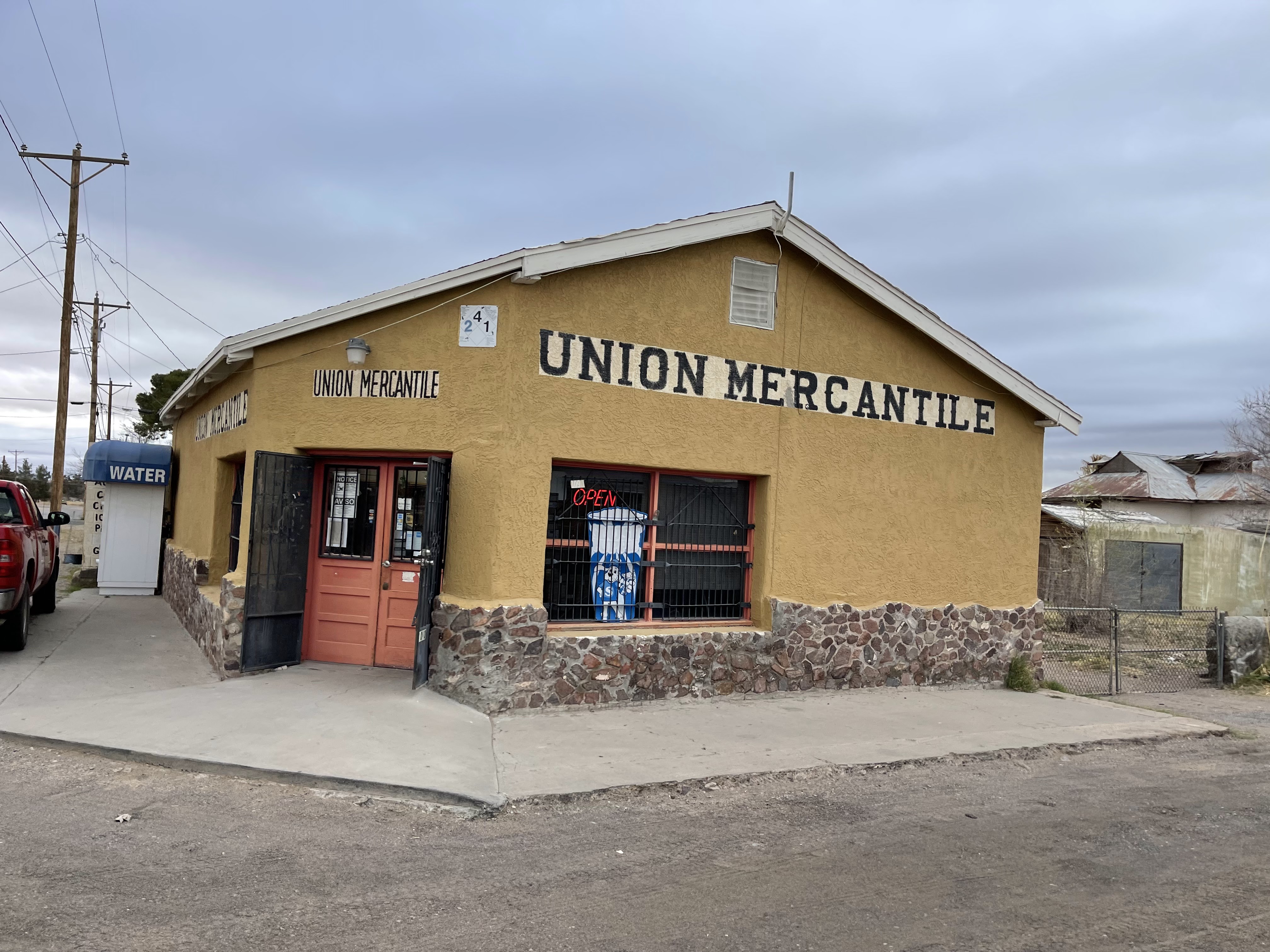
We rolled into Hatch around the 65 mile mark, stopped at a gas station for some resupply for the night and next morning, then proceeded immediately to Sparky's for green chile burgers! YES!
Hatch, NM is widely known as "The chile capital of the world"
After some much needed food, we headed out for what we presumed to be a brutal 8-9 miles of pavement, going directly west, into what seemed to be the strongest wind of the day; and it trended uphill the whole way as well. Holyyyyy crap that was the craziest wind I have ever ridden in, having to pedal to keep moving on the few descents, and, again, having to stand up to pedal the single speed into the wind on flat ground. What a crazy experience! It took us about an 45-55 minutes to go 8 miles on pavement, haha!
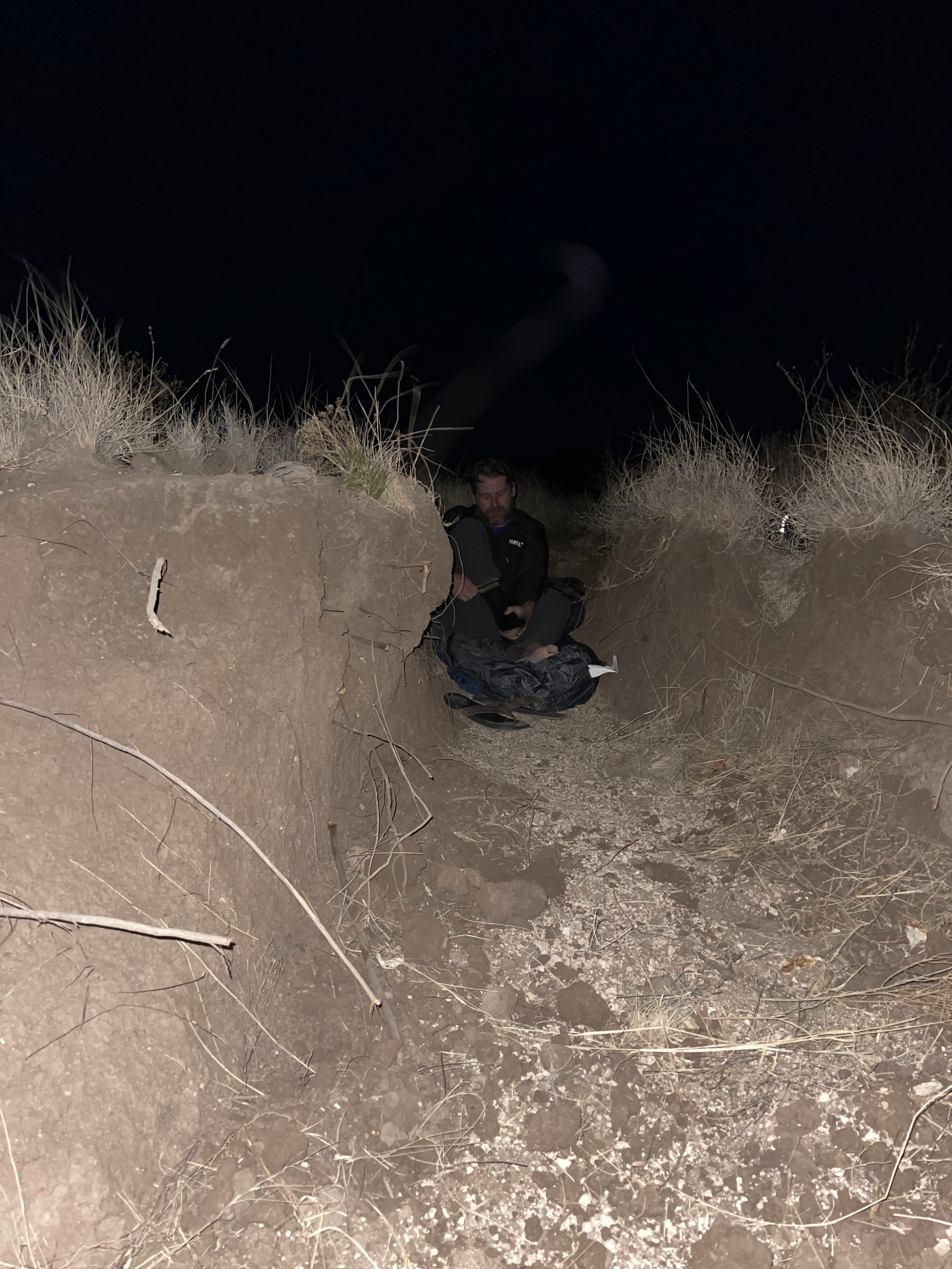
Finally! We made it to our left turn that gave us a bit of a cross/tail wind. This was kind of a milestone in our trip because this was the road that would take us up over our first true mountain pass of the route. We had tentatively planned to get to the top and maybe push over to a lower elevation on the backside to camp for the night, depending on time. In hindsight, boy were we glad we didn't! More on that shortly. This road was smooth gravel at first, slowly transitioning into a very rocky traverse of the cow pastures, with some rocks embedded in the ground and many more that were loose, constantly altering our lines. The evening shadows grew longer as the sun made it's own descent down to the the craggy, mountainous horizon. There was a dense haze in the air, which, I assume, was dust from all of the wind!
We continued up the road, discussing our options. We decided to make our way up to the base of the climb and get some sleep for the night. We looked around and decided on a small flat area without too much cow manure, complete with a small wide ditch carved from water run-off. The wind was blowing in the direction of the long axis of the ditch, so Justin and I leaned our bikes against each other, at the mouth of the ditch, draping our jackets from the sides, in an attempt create a wind screen. And I think it actually worked well.
I had a hazy IPA night cap and climbed into my sleeping bag around 8:30pm or so. I basically tossed and turned all night, first checking out the expansive sky of glistening stars above me, but then had to cover my face from the spotlight provided by the moon. I listened to the coyote banter several times throughout the night, once getting pretty close to us...they make some crazy noises. And then, there it was...the dreaded need to pee while warm and cozy in a sleeping bag.
Now, I wasn't going to put this in here but I'm a pretty transparent person and I think people should read the most real and accurate account of the trip. So, when I'm in a tent, I usually have a big bottle to pee in so I don't have to get out in the middle of the night, especially when cold. So, why not utilize the same strategy in a sleeping bag? I sat up on my knees in the sleeping bag (brand new, by the way), aligned the bottle with, well you know....and peed for several seconds before I had a feeling something wasn't right. I reached down to feel the bag below the bottle...yep, peed in my brand new sleeping bag. It wasn't a full pee, but it was some pee. Enough pee that I had wetness in my bag. Well shit. WTF was I to do? Sleep in the pee bag, that's all I could do. I didn't have socks on and could feel wetness on my feet, so I just threw my socks on and tried to go back to sleep. Stuff happens, I guess, and you just have to deal with it. Keep your judgements to yourself, haha!! I have no shame.
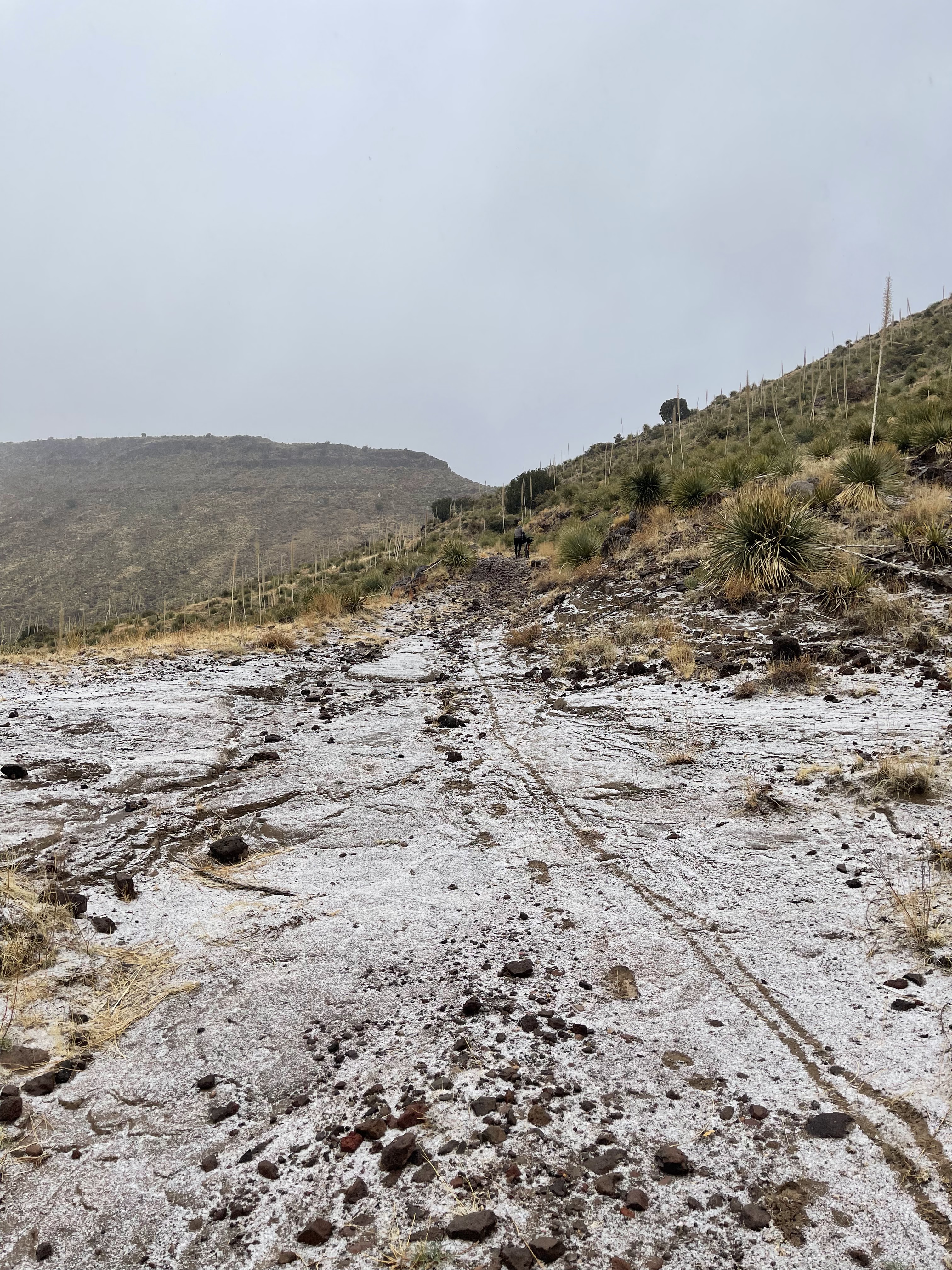
We got up around 6am under a dark but obviously overcast sky and started packing up. My sleeping bag was dry, by the way. I had a poptart, a moonpie, and a couple of snickers brownie bites, which isn't near enough to get long day going, but it sufficed. The road meandered through more rock-studded pastures, passing a few cows and an abandoned shall of a stone farm house, slowly climbing higher and higher towards the pass. Earlier, upon awakening, I thought I heard a few sprinkles hit my bag, but then decided maybe not. Well, I was right, and it started started sprinkling again. This was bad as I had opted to leave my rain jacket at home since "it doesn't rain in the desert". There was a 0% chance of rain in the forecast the day we left. That's a known no-no in outdoor adventures....when you leave your rain gear home, it rains! Well, it only rained briefly before turning to sleet. My wahoo was showing 34 degrees, down to 31. We finally got to the steepest portion, which was hike-a-bike up to the pass. By this time, it had changed to snow and was coming down pretty good. I was ecstatic because I love snow, and, we were experiencing a rare snow in the desert!
After crossing the pass, the descent was pretty tricky. It was, by no means, a quick rip down the mountain. It was littered, even more so than the ascent, with thousands of slick rocks that were not embedded. It was rideable, but took some finesse. It was a short'ish descent because we were in a saddle between two peaks. Here we encountered what I deemed "snow-crete" as the fine dirt/sand combined with a little moisture made a concrete-like mixture that caked up the tires and stopped them from spinning. We cleaned them off a couple of times, made our way to the next peak, and then down a ripping paved descent back to the high desert plains with thoughts of beer and burgers dancing in our heads.
After it took 2 hours to go 8 miles, we were back on fast-rolling ground in the high desert plains. We were nearing the end of our water supply and stopped at a cow tank to filter some water. Doesn't it look delicious?
From here, we had about a 16 mile traverse of the plains on mostly dirt but also some old chip seal pavement, with a pretty good descent ahead. There's always a good descent ahead. We skirted by disgruntled cattle, hit the descent, first down some fast but sketchy sandy sections, and then into a neighborhood, and finally into Mesilla, where The Spotted Dog brewery awaited our arrival, sitting on route at about mile 123.
Green Chile Philly and Garlic Fries, The Spotted Dog Brewery
As we ate, we discussed our plan. The mountains in the distance, now covered with snow, which was new from the day before, were draped in low storm clouds and what looked like rain, in the lower sections, where we were headed. We decided to just keep pushing forward. You get what ya get.
The route is a figure 8 and goes right back by the van in Las Cruces, so we stopped to change clothes and what not. We weren't there long before getting back on the route, headed towards the ominous looking mountains, on some easy roads. However, sometimes a couple beers and some heavy food have a deleterious effect on one's ability to pilot a bicycle appropriately. Here I have captured one of those moments for your viewing pleasure:
Motormile Racing's Finest, Mustin Jace, on flat pavement, still clipped in
This next section was probably my favorite on route. We climbed up to the edge of the high desert and then turned back towards the city, utilizing a 13-15 mile singletrack descent. The sun was getting low, light was dissipating, and rain drops were beginning to fall. This meant we were all in a paceline, ripping the singletrack, running from rain and darkness. Holy crap what a freaking blast we had. Nearing the end where we re-entered the city, I was pretty much soaked and shivering. It was dark. It was still drizzling and we had no tents or real rain gear. We descended into the town of Vado, to a gas station with a restaurant attached, where we ate and researched our options. We also met back up with Ian here. I forgot to mention it earlier, but we had gone ahead of him and Austin as our paces differed. Unfortunately, Austin had to pull the plug, and this is how Ian came to find us to meet up. We opted for a hotel about 10 miles down the road, in the town of Vinton, where we actually ran into a legendary Chattanooga cyclist that Nick knew. (Durward "Dur" Higgins, if you know). What are the odds!?
After our hotel stay and best western breakfast, we got back on route around 8:00am. Day 3 was underway! We started around route mile 170 with some quiet, flat, paved back roads, passing through a quant little town with what seemed to be a scarcity of people.
Pavement turned to dirt and the flat turned uphill. But it was small, again, climbing only 200-300 feet to the high desert. The day proved to be a bit different than the previous days. We had tailwinds most of the day, and extremely flat, easy riding. It was kind of nice that the easiest of days was the last day.
We were again in the OM-DP National Monument conservation area! That place is expansive. We passed by Killbourne Hole, and stopped for a quick peek. This is maar volcano and former testing site for the Apollo missions. Pretty awesome to see.
Killbourne Hole
Nick had decided to sit out the third day and was therefore driving around in the sprinter van. We had been coordinating, trying to meet up with him on route. As we passed another death sign and moved back into cow territory, I looked back and saw a cool sight, which was Nick speeding down the dirt road, with a trail of dust in the air, behind Ian, Cody, and Rowdy Randall, looking like a scene out of the movie Twister.
We refilled a bottle or two, had some snacks and a cerveza, and bid Nick farewell for just a couple of more hours; we only had about 35-40 miles to go.
The next section was just as flat, but looked more like we were crossing the Serengeti.
After crossing the Serengeti, there was an option to cut out about 15 miles of the route by crossing a railroad track, which we opted to do. It was just some more flat, straight roads and it would still be 240 miles vs 255 or something like that. This was about the time that we turned into the wind and had about 10 miles of perfectly straight gravel road to wrestle with it. We were headed back towards Las Cruces, but not before another 'nice descent' ahead. After a long, hard pull, working for Justin and Rowdy Randall, pulling them to the edge of the descent, and taking a pic of the two starting down it (upon request!) , I was dropped and left for dead, spinning like a hamster into the heavy hand of the wind, trying to keep them in sight. Scoundrels!!
At the bottom, we again crossed the bone-dry Rio Grande, regrouped, and pedaled the 4-5 miles of gravel and pavement back into Mesilla, which is just a few miles before the finish, where we met Nick at La Posta De Mesilla, which provided a huge selection of specialty margaritas and delicious authentic Mexican food. We laughed and chatted about our awesome experience as well as our trials and tribulations out on the route. We left there with full bellies and happy hearts.
The route was everything I imagined it would be. And I am so thrilled to see friends get into bikepacking and taking on a route that is not only physically, but also mentally challenging.
And here is Rowdy Randall the Peaceful Parrot Whisperer, talking to his people at the restaurant.
We said our goodbyes and made our way back over to El Paso, where Hannah lives, and was hosting us for the night before flying out the next day. (Thanks again, Hannah!) We lounged, loved on her dogs, cleaned the bikes, packed them up for the flight home, and we were out! Another amazing adventure for The Bad Idea Club ™. Thank you all for reading!
CHEERS!!!
Gear:
Pivot LES SS, 34:18 gearing.
Rockgeist custom frame bag and tank bag/feed bags.
Revelate seat bag and bar harness.
Mountain hardware 30 degree bag and nemo pillow in 11L dry bag and therma-rest neo air x-lite sleeping pad, all in the harness on the front.
Warmer clothes/gloves/socks and rain fly from my tent, to put my sleeping pad on top of to prevent punctures, all in the seat bag.
Extra bottle, food, headlamp, tool kit in frame bag.
Anker 15000 mAh power bank and iphone and micro usb cables in the tank bag.
Okay...I'm seriously going to make this an abbreviated race write-up for the first time ever. This was my 3rd year in a row racing the "Lite" version of the Huracan, which means the more "gravel" version, with no major single track and no water crossings. It's just really fun and it's better for me so I don't have to burn as much PTO as I can get down there, get it done, and get home with only Monday off work. I had a new bike build that was completed by the wonderful Tom Bryant at Owen Cyclery in Chattanooga and I was pumped to race it. It's a Rodeo Labs Flaanimal 5.0 with SRAM AXS and some other fun bits. Our route started at 7:45am. After some chats with friends, we were off. Last year, I got a time bonus for the hole shot so I made sure to go for that again. I quickly realized I wasn't sure where the imaginary line for the hole shot was as I backed off around the gravel parking lot loop and then I was quickly passed by Chris Thorpe wh...
Since the last long race that I had jumped into was back in February, I had been itching for a big adventure. I had created my own 400 mile mixed surface loop out of Tellico Plains, TN and was thinking about doing it the weekend after Halloween. However, once I realized that the Cohutta Cat was the same weekend, and I had quite a few friends going, it was an easy decision to throw my hat in the ring and save my loop for a later date. The route is a figure-8 loop that starts/ends at Mulberry Gap - Adventure Base Camp in Elijay, GA; the figure-8 crossing occurs in the town of Blue Ridge, GA. It's 266 miles of single track, double track, gravel, service roads, pavement, and everything in between and boasts about 30,000 feet of elevation gain. And it was taking place during peak leaf season with cooler temps, everything my dreams are made of! The route was created by Daniel Jesse and the race director is now Matt Schweiker. Going against my DNA, I started prep...
Bones to Blue is an impressive 250-mile figure-eight loop starting and ending in Truckee, California, featuring some 90% single track and over 30,000 feet of elevation gain. After meeting Kyle Quinn in Salida, CO during my trip out for Vapor Trail, I saw him do this race and was quick to inquire. His positive descriptions and post-race considerations of relocating to the area had me all in for exploring the route myself! After an uneventful flight into Reno and late night drive in to Truckee (save for Rasch waiting on me in the airport and stuffing his bike bag into my tiny Hyundai rental and making me drive him to a nearby hotel because he thought his delayed flight was going to render him unable to get into his hotel in Truckee), I arrived at my hostel-style "hotel" room with communal bathrooms and living spaces for some much needed rest. The bike and bike bag had to stay in the common area because the room was only big enough for me, my carry-on, and the bed. The next da...


Looks like good times! Pretty sure I saw you all at Spotted Dog...I should've stopped in. Great write-up - bummer about the sleeping bag incident :)
ReplyDeleteNice write -up. I can't believe a freakin' white-out at White gap.... beastly bad ideas y'all have !! :-)
ReplyDelete